Informative for local history researchers and genealogists - © 2021
 |
 |
 |
 |
 |
 |
 |
 |
 |
 |
 |
 |
 |
 |
 |
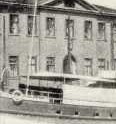
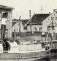
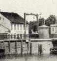
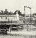
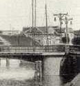
| Image ID | 000027 | ||
| Description: | The Karlsbrücke (Carl's bridge) was close to the mouth of Dange river. As a drawbridge (operated electrically) it was opened up on both sides. more ... | ||
| Shot: | -- | ||
| Site map: |
|
||
| Today: |
|
Source: | Book: Das Memelland in alten Ansichtskarten - page 27, Publisher AdM, 2002 |
 previous